


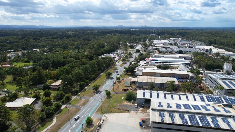
A new vision for Narangba East would open parts of the district to suburban housing and industrial development while retaining other pockets as rural residential land, as City of Moreton Bay asks residents to weigh in on how the 1020-hectare area should change.
Council has released its draft Future Directions Report for the Narangba East Rural Residential Investigation Area after almost three years of planning investigations and consultation.
Public feedback is open until 4pm on Friday, 9 October 2026. The report does not rezone properties or approve development, but will help shape a future planning scheme amendment governing what can eventually be built across the area.


Read: Narangba Flying Fox Colony More Than Doubles as Management Plan Remains Unresolved
Housing Is Back in the Picture
One of the most consequential elements of the updated vision is the amount of land identified for future housing.
The Queensland Government placed conditions on Council’s current Temporary Local Planning Instrument (TLPI), including a requirement to provide for housing as well as employment within the affected area. Several parts of Narangba East are consequently identified for residential development.
The draft envisages small-lot detached homes, duplexes, townhouses and retirement living. Emerging Community areas would generally have a minimum net residential density of 20 lots per hectare, with buildings around a maximum 12 metres, or three storeys.
Mayor Peter Flannery said Narangba East had long been identified as an area capable of supporting Moreton Bay’s growth.
“It’s no secret that growth is coming to City of Moreton Bay and parts of Narangba East have long been earmarked as a key location to support future urban growth,” Cr Flannery said.
He said the city’s population was projected to grow from roughly 530,000 today to one million over the next 30 or so years.
Future housing: Small-lot houses, duplexes, townhouses and retirement living in designated Emerging Community areas.
Employment land: Light and general industry around parts of the existing industrial precinct, including the Old Gympie Road area.
Rural residential: Some established acreage areas would retain their existing rural-residential role.
Environment: Environmental corridors and links would be retained or established, with the investigation area sitting within a Koala Priority Area.
Infrastructure: Significant road and servicing upgrades would be needed as development occurs.
What happens now: This is a proposed planning direction, not a rezoning. Formal changes would require a planning scheme amendment and further consultation.
Industry Stays, but With Buffers
Employment land remains a sizeable part of the vision, particularly around existing industrial areas near Old Gympie Road and Richards Road.
Both light and general industry are proposed, with controls intended to manage noise, vibration, odour, lighting, traffic and operating hours near homes. General industry would generally be separated from future urban residential areas by at least 250 metres, with lower-intensity light industry providing a transition in some locations.
Not every acreage neighbourhood would change. Dean Drive, Casino Court, Gavin Court and Jane Place are proposed to remain Rural Residential because they sit within an environmental health buffer west of Old Gympie Road.
Earlier Consultation Revealed the Fault Lines
Council already has a sense of where some of the debate will lie.
During consultation in 2025, it received 108 survey responses, while another 99 people took part in 14 small-group sessions. The participants were self-selecting, so the figures cannot be treated as a poll of Narangba East as a whole, but they show considerable concern about both major forms of development being considered.
Thirty per cent of survey respondents opposed residential development and another 24 per cent expressed concern. Twenty per cent were supportive and 16 per cent cautiously open.
Industrial and employment development met stronger resistance: 40 per cent opposed it and 29 per cent were concerned, compared with 15 per cent supportive and 7 per cent cautiously open.
Roads, infrastructure, environmental protection, neighbourhood character and certainty for existing landowners also emerged repeatedly. Roads and pathways ranked as the most important immediate priority, while protection and enhancement of the natural environment came first when participants looked 20 to 30 years ahead.
Growth Will Depend on the Infrastructure
Old Gympie Road and New Settlement Road would eventually need significant upgrades, including provision for a four-lane standard. Callaghan, Mackie and McPhail roads are also identified for future work, along with an extension of Marks Road to Callaghan Road.


Council also wants better public transport links between Narangba railway station, Narangba East and destinations including North Lakes.
The report identifies what would be needed to support future development rather than setting out a fully funded construction timetable. Delivery would occur over time and depend on development, funding and coordination between Council, the State Government, utilities and developers.
Likewise, a future change in zoning would not force an existing landowner to sell or redevelop. Lawful uses could continue, potentially leaving established acreage properties beside areas that change progressively over time.
For some residents, the question may therefore be not only what Narangba East becomes, but how quickly the transition happens and what infrastructure arrives with it.
Read: More Details Emerge as Narangba Heights Shopping Centre Takes Shape
The Map Is Not the Final Word
The current TLPI remains in place while the longer-term framework is settled and is due to expire in June 2028 unless repealed earlier.
The consultation now under way is focused on the broad direction for Narangba East. A second opportunity for public input will come when the proposed planning scheme amendment sets out the formal planning controls.
Deputy Mayor Jodie Shipway said residents would have another chance to comment.
“You can have your say on the draft Future Directions Report, but it won’t be your last chance to provide feedback on the future of the Narangba East Rural Residential Investigation Area,” she said.
Submissions from this round will help inform the next stage. Until the planning scheme amendment process is completed, the new Narangba East map remains Council’s proposed direction rather than new zoning.
Published 8-September-2026


CLICK ANY LOGO TO SEE PUBLICATION