


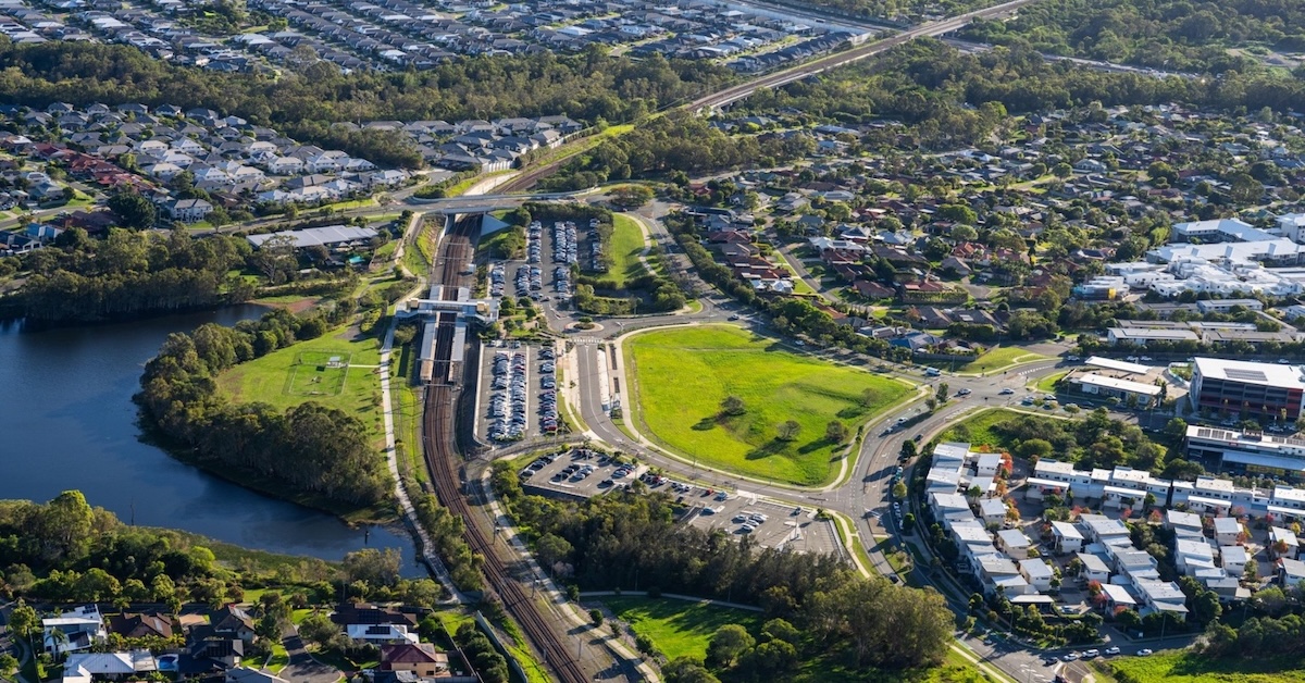
The stretch of land opposite Mango Hill railway station could eventually accommodate buildings of up to six storeys, bringing a noticeably different scale of housing to the Meyers Circuit precinct.
But the shape of the neighbourhood will depend on more than building heights. Parking, access to surrounding streets and the way new homes connect with the railway station will all influence how the development fits into this part of Mango Hill.
Public consultation closed on 19 October 2026, following the site’s declaration as a Provisional Priority Development Area on 25 September. The designation allows Economic Development Queensland (EDQ) to establish planning rules for the precinct, with a draft Provisional Land Use Plan already in effect while submissions are reviewed and the final version is prepared.
A Different Scale of Housing
The draft plan provides for residential buildings ranging from two to six storeys, potentially introducing taller housing into an area where lower-rise development is more familiar.
These heights indicate what the planning rules may accommodate, rather than buildings that have already received development approval. The eventual scale and arrangement of homes will depend on the proposals submitted and how they meet the applicable requirements.
For neighbouring properties, building placement will be particularly important. The distance between buildings, setbacks from property boundaries and the treatment of upper levels can influence privacy, sunlight and the appearance of the surrounding streets.
Landscaping and open space are also part of the planning requirements, along with the way buildings meet the street. These details will help determine whether the new precinct feels connected to the existing neighbourhood or noticeably separate from it.
Parking Beyond the Station Platform
Mango Hill railway station is one of the site’s most significant advantages. Future residents would have an established rail connection nearby, offering an alternative to driving for some everyday journeys.
That convenience does not remove the need for parking or suitable vehicle access. Residents, visitors, deliveries and service vehicles will still need to move through the precinct, while surrounding streets must continue to accommodate existing traffic.
The draft plan addresses parking, driveways and the safe movement of vehicles, with particular attention to how these features affect the street frontage and surrounding road network.
Walking and cycling connections are equally important. Although the station sits opposite the site, the convenience of that location will depend partly on the routes available to pedestrians, the placement of crossings and how vehicle entrances interact with footpaths.
A short distance on a map does not necessarily translate into a straightforward walk, particularly where people must navigate busy streets or vehicle access points.
The detailed parking layout, road access and pedestrian arrangements will be considered through subsequent development applications. No final site-specific traffic or parking arrangements have been established in the planning information reviewed.
The Housing Proposal Behind the Plans
The planning process follows earlier announcements involving Coast2Bay Housing Group and Azure Development Group.
Coast2Bay was associated with 56 proposed affordable rental apartments, while Azure’s townhouse component was initially described as comprising 61 homes. Together, these formed the 117-home proposal announced in July, although subsequent reporting referred to a possible increase in the townhouse component to 68.
Those figures remain indicative rather than a confirmed final development total. An earlier estimate of up to 250 homes referred to the site’s potential housing capacity, not an approved construction programme.
The affordable rental apartments would provide a housing option close to public transport and nearby services, alongside the separately proposed townhouses. The final mix and layout will depend on the development proposals ultimately assessed.
EDQ previously indicated that the land-use plan was expected to be finalised in December 2026. As at 4 November, consultation findings and any resulting amendments had not been publicly confirmed.
For Mango Hill, the next decisions will shape more than the number or height of buildings. They will influence how residents enter and leave the precinct, walk to the station and share the surrounding streets with an established neighbourhood.
Published 4-Nov-2026


CLICK ANY LOGO TO SEE PUBLICATION